- Animals
- ›Chordates
- ›Vertebrates
- ›Reptiles
- ›Turtles and Tortoises
- ›Pond and Box Turtles
- ›Deirochelyine Turtles
- ›Graptemys
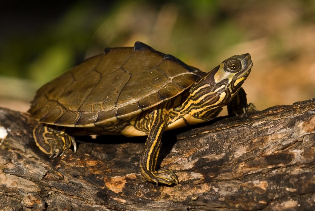
Alabama Map Turtle
Graptemys pulchra
The Alabama map turtle (Graptemys pulchra) is a species of emydid turtle native to the southern United States. Differentiation from other turtle species includes a black stripe running down the center of its back with knobs extruding from it, but these projections wear down with age. T.H. Bean and L. Kumlen first collected the Alabama map turtle in July 1876 from a lake near Montgomery, Alabama. Type locality for this species is Montgomery County, Alabama. German zoologist Georg Baur described and named the Alabama map turtle in 1893. The genus Graptemys includes nine species of mostly aquatic turtles.
From the article Alabama map turtle on Wikipedia (CC BY-SA), quoted section by section
Description
Nine species of Graptemys turtles could allow confusion in distinguishing G. pulchra from other species in the same genus. A few key diagnostic features set the Alabama map turtle apart. The black stripe down the center of its back with knobs extruding from it is a diagnostic characteristic for this species that separates it from other turtle species. Adult males range from 9.0–12.7 cm (3.5–5.0 in) in straight-line carapace length and retain most coloration and pattern from its juvenile stage. Females range from 18.0–29.2 cm (7.1–11.5 in), have extremely large heads for crushing snails and mollusks, and lose a majority of their markings and patterns, becoming drabber than juveniles and males. Carapace (upper half of shell) color can be olive to dull green with a slightly visible black stripe in adults. Juveniles exhibit a dark stripe running down a more olive carapace. The outermost edge on the upper half of the shell usually contains light reticulate markings and the scutes (scale-like structure) contain a yellowish bar or semicircle. Dark rings are usually present on the lower surface of each outer scute. It contains a hingeless yellow plastron (bottom half of shell) notched in the back. A narrow black margin borders the edge of each scute. It has a brown to olive head with a large mark that ranges from light green to yellow located between and behind the eyes. …
Range & habitat
The Alabama map turtle has a unique location to its habitat in the Southeast. It is endemic to the Mobile Bay drainage basin and inhabits the lotic (flowing water) areas of Alabama, Georgia, Florida, Mississippi, and possibly Louisiana. It ranges from the Pearl River in Mississippi and Louisiana eastward to the Yellow River in Florida and Alabama.
Wikipedia: “Geographic distribution”
What it does
Water temperature, certain river characteristics such as prey items, variations of the species in different drainages, along with any known disease or parasite problems, is vital information to provide ideal habitat for the Alabama map turtle. Seasonal activity is determined mainly by water temperature. In one location, temperatures below 19 °C (66 °F) resulted in severe decline in feeding and activity, complete hibernation of the population did not occur, and no significant interspecific competition with other turtle species occurred. G. pulchra is found mainly in large coastal plains streams with large mollusks populations. Four geographical variants include one in the Pearl River drainage, a second in the Pascagoula drainage, a third in the Mobile Bay drainage, and a fourth in the Escambia and Yellow River drainages. No deleterious parasitism was found, but a single ectoparasite (Placobdella sp.) (leech) was on turtles during spring. The most common intestinal parasite was an acanthocephalan (Neoechinorhynchu), but was found in less than 25% of adult population. One adult female possessed a fluke (Telorchis sp.) in its small intestine. A sporozoan (Myxidium chelonarum) was noted in the bile duct and gall bladder of the Alabama map turtle.
Wikipedia: “Ecology and behavior”
Where it lives
Recorded sightings
—
geo-referenced records in GBIF, from museums, herbaria and field observers.
Drag the globe to turn it. Dots are where records exist, not a range map; darker means more records.
In the stacks
Searching the stacks…
Every page naming Graptemys pulchra in the Biodiversity Heritage Library →
This page is assembled live from iNaturalist, GBIF, Wikipedia, the Source Library and the Internet Archive. It is not yet part of the hand-edited codex. iNaturalist taxon 39846.